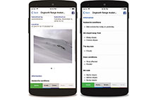
Ski Haute-Gaspésie
Mobile App

The essential tool
in the backcountry

All the resources you need to plan your backcountry skiing trips in the Gaspé Peninsula. From descriptions of more than 130 ascent and run routes to avalanche reports, weather conditions and the Mountain Information Network (MIN), it’s a must-have!

A good outing preparation that is accessible to all, simply.

Numerous tools to refer to before each outing in the backcountry to feel more confident.

Application logo - version gratuite

Free version

Now available free of charge to all, the Ski Haute-Gaspésie app gives you quick access to essential information for your outing in avalanche terrain.

Available every day, access the forecast directly from your phone. Once downloaded, you can consult it at any time, even without access to a mobile network.

To get the latest information on mountain conditions, check out the snow report and current data from our automated mountain weather stations. We also offer a specific weather forecast for the peaks of the Chic-Chocs.

What’s the weather like in the Gaspésie National Park? This view of Mount Albert will give you a good idea of the current conditions and the amount of snow that has fallen on Powgouin.

Is your route in simple, challenging or complex terrain? Use the Avalanche Terrain Exposure Scale to find out what level of exposure to expect.

Consult the topographical maps of the relevant sector. They are available with the overall level of precision.

View and submit MIN reports directly from the app to keep the community informed of mountain conditions. Every report is valuable!

Application logo - version pro

Ski Haute-Gaspésie – Pro Membership

In addition to all the tools offered by the free version, enjoy unlimited access to all the features related to the map and some additional tools to improve planning. Simplify your days in the mountains!

Make sure you have the most up-to-date Chic-Chocs Backcountry Touring Guidebook with you! It contains all the details and photos of more than 130 ascent and run routes.

View your position in real time on the map using your cell phone’s GPS, even without a cellular network.

A topo map is great, but you can also achieve a higher level of precision by zooming in on the map: you will then switch from the topographic map to the satellite map and access more details. Satellite maps can be downloaded in advance for use outside the cellular network.

Would you like to overlay additional details on your map? What is the slope angle of the run you would like to ride? Find this information by selecting the layer of your choice.

Not only do you have access to the most recent image from the webcam, but you can also access images from the last 24 hours to see how the situation has evolved and how fast the snow has been falling.

Consult the hourly weather data from the automated mountain stations for the last 24 hours. This will give you a precise idea of the wind direction and strength at higher altitudes, as well as the exact temperature.

Enjoy ad-free browsing!

And much more!

$4.99 / year

AvQc - appli - Carte topographique

Topographic and satellite map

Find the routes

and locate yourself on the map

Choose the layer of the map that suits you best, either the one with the Avalanche Terrain Exposure Scale or the one with the slope angles. This layer can be overlaid on the topographic or satellite map, depending on the zoom level you display. You will have a much better idea of the terrain you plan to navigate.

Detailed itineraries

Easy access to details

you need

Access a detailed description of each ascent and run route, including the minimum and maximum slope angle, aspect, elevation gain, distance, route characteristics, maximum Avalanche Terrain Exposure Scale rating, description and photos. This information will help you make the right decisions about your route and gauge its level of difficulty based on your skills and knowledge.

AvQc - appli - Itinéraires

Simplified access to tools

to prepare for your outing

AvQc - appli - Outils

Avalanche Forecast

From December 1st to April 30th, the avalanche forecast is published daily to guide and help you plan your outing.

AvQc - appli - Bulletin

Alpine Weather Forecast

Avalanche Québec offers a weather forecast specifically for the Chic-Chocs peaks. It is prepared twice a week by a professional meteorologist.

AvQc - appli - Outils météo

Slope angle

Combine the slope angle layer with the topographic map to get a better idea of the slope relief and find the route to take. If the contour lines weren’t clear enough for you, the colors are very obvious!

AvQc - appli - Outils angle de pente

an undeniable asset

for mountain safety

AvQc - appli - MIN

Quick access to the Mountain Information Network (MIN) to view and publish condition and avalanche reports.

AvQc-PageAppli-Securite-1-minvoir

Go to
MIN reports

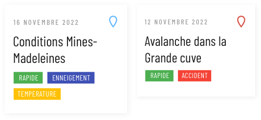
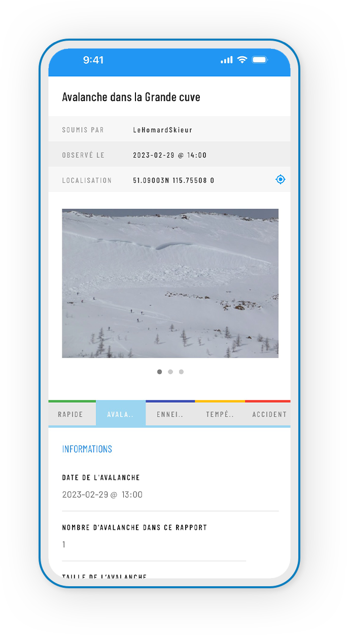
View and submit MIN reports directly from the app to share the state of mountain conditions or to report an avalanche. You will contribute to mountain safety by sharing valuable information for the community and forecasters!

AvQc-PageAppli-Securite-2-minajout

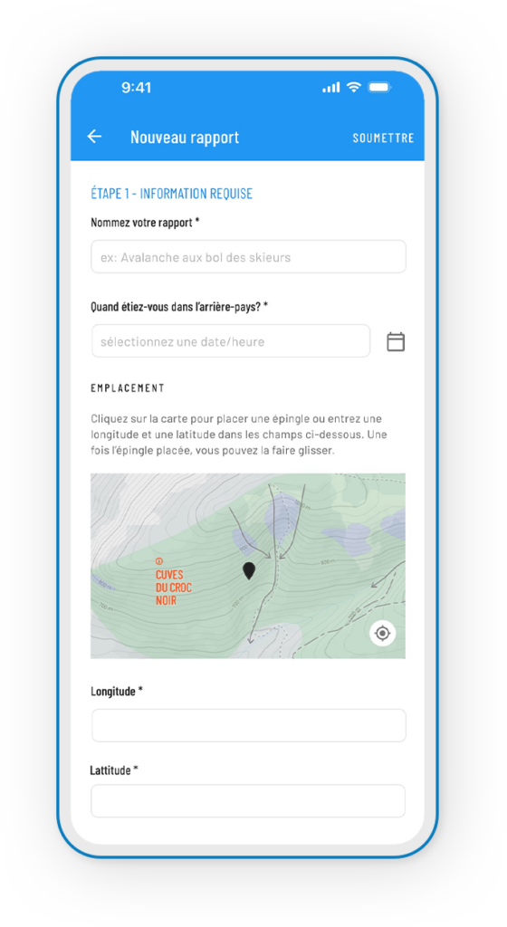
Submit a detailed report

All information is valuable, even if you believe your knowledge is limited. It's always worth sharing, especially your photos. Check each tab in the report to see which ones apply to what you would like to communicate.
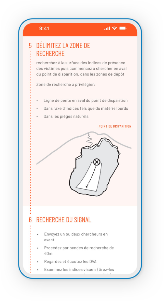
App - carte sauvetage - icon
AvQc-PageAppli-Securite-3-sauvetage

In case of rescue

If you see or hear an avalanche and feel the snow moving, shout “AVALANCHE!”. In the event of an accident, you may lose track of what you learned in your avalanche safety courses. That's why the companion card outlines, step by step, the procedure for optimal rescue.
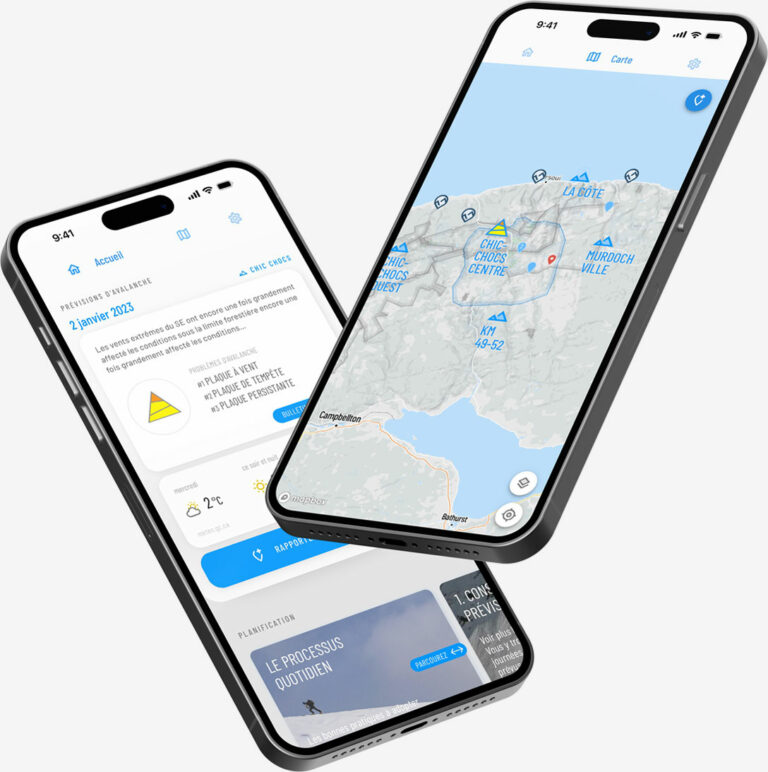
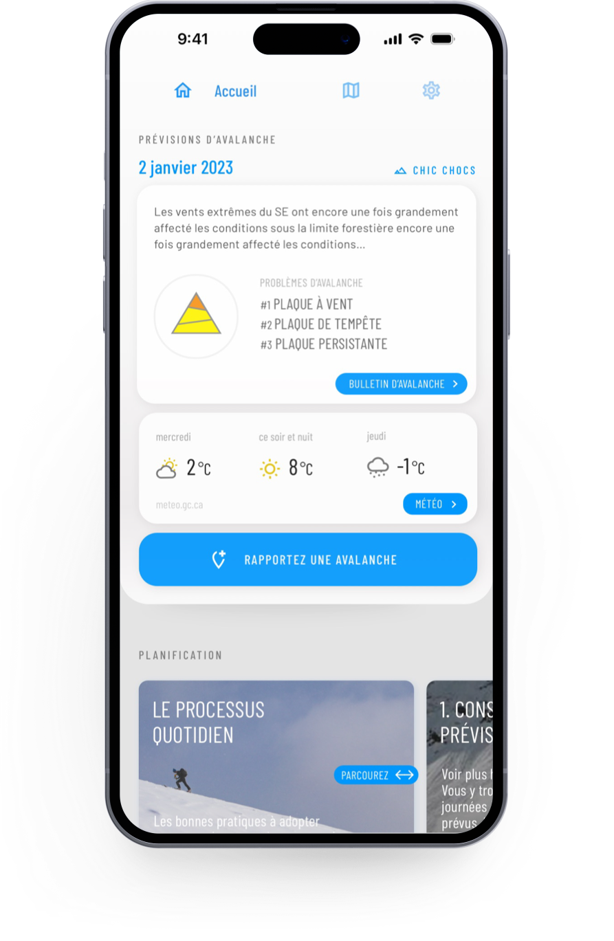
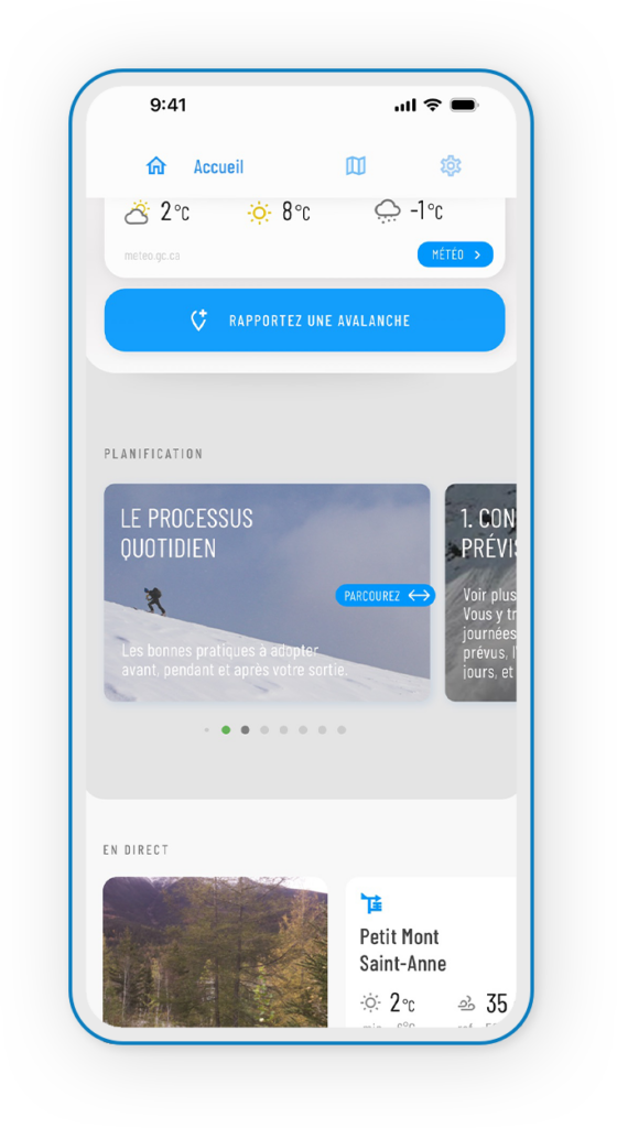
AvQc-PageAppli-Securite-4-processus

Daily Process

Professionals and experienced outdoor enthusiasts follow a daily process before going on a hike. This allows them to make consistent and well-considered decisions. It's simpler than it looks, check out the steps to follow.

and much more

at your fingertips

  • The location of safety equipment caches, refuges, and shelters;
  • The classification of the type of ascent route ;
  • Environment Canada’s detailed public forecasts and links to additional resources to complement the weather forecast;
  • An explanation of how the Avalanche Terrain Exposure Scale works.
  • A filter to display the MIN reports for the last day or for the last 3 or 7 days;
  • The contact details of activity providers, including local ski resorts, FQME sites and guided service providers.
Scroll to Top

BE OUR EYES ON THE GROUND

By sharing your observations, you contribute to the accuracy of the avalanche bulletin and to the safety of all Chic-Chocs backcountry riders

Create a MIN report on the Mountain Information Network to share an avalanche observation or incident (public)